My Map Blog - FSU Assignment

Wednesday, July 30, 2014

Isopach


http://cartographic-catalog.blogspot.com/2012/04/isopach-map.html

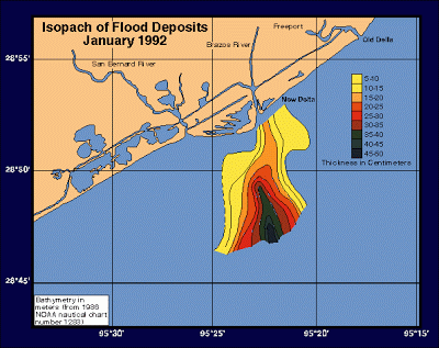
Isopach maps are useful for geologists.  Isopach maps use contour lines representing areas of equal thickness, whether vertically or horizontally.  Above is an example of an Isopach map showing flood patterns.
Posted by Unknown at 8:01 PM
Email ThisBlogThis!Share to XShare to FacebookShare to Pinterest

No comments:

Post a Comment

Newer Post Older Post Home
Subscribe to: Post Comments (Atom)

About Me

Unknown
View my complete profile

Blog Archive

  • ▼  2014 (50)
    • ►  August (10)
    • ▼  July (40)
      • Population Profile Graph
      • Index Value Plot
      • Univariate
      • Bivariate Map
      • Unclassed choropleth
      • Histogram
      • Box plot
      • Stem and Leaf
      • Similarity Matrix
      • Correlation Matrix
      • Star Plots
      • DOQQ
      • DEM
      • DLG
      • DGR
      • Isopleth
      • Isopach
      • Isohyet
      • Isotach
      • Isobar
      • LIDAR
      • Doppler Radar
      • Black and white Aerial photo
      • Aerial Infrared
      • Cartographic Animations
      • Statistical Maps
      • Cartogram
      • Flow Map
      • Isoline map
      • Proportional circle map
      • Choropleth Map
      • Dot Distribution Maps
      • Propaganda Map
      • Hypsometric Map
      • PLSS maps
      • Cadastral Map
      • Thematic Map
      • Topographic map
      • Planimetric Map
      • Mental Map
Awesome Inc. theme. Powered by Blogger.